1. Victoria Falls
Victoria Falls is a waterfall on the Zambezi River in southern Africa, which provides habitat for several unique species of plants and animals. It is located on the border between Zambia and Zimbabwe and is one of the world's largest waterfalls, with a width of 1,708 m (5,604 ft).
Archeological sites and oral history describe a long record of African knowledge of the site. Though known to some European geographers before the 19th century, Scottish missionary David Livingstone identified the falls in 1855, providing the English colonial name of Victoria Falls after Queen Victoria. Since the mid 20th century, the site has been an increasingly important source of tourism. Zambia and Zimbabwe both have national parks and tourism infrastructure at the site. Research in the late 2010s found that climate change caused precipitation variability is likely to change the character of the fall.
David Livingstone, the Scottish missionary and explorer, is the first European recorded to have viewed the falls on 16 November 1855, from what is now known as Livingstone Island, one of two land masses in the middle of the river, immediately upstream from the falls near the Zambian shore. Livingstone named his sighting in honour of Queen Victoria, but the Sotho language name, Mosi-oa-Tunya—"The Smoke That Thunders"—continues in common usage. The World Heritage List officially recognises both names. Livingstone also cited an older name, Seongo or Chongwe, which means "The Place of the Rainbow", as a result of the constant spray.
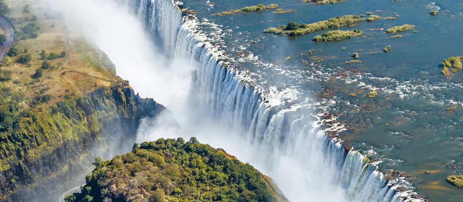
While it is neither the highest nor the widest waterfall in the world, the Victoria Falls are classified the largest, based on its combined width of 1,708 metres (5,604 ft) and height of 108 metres (354 ft), resulting in the world's largest sheet of falling water. The Victoria Falls are roughly twice the height of North America's Niagara Falls and well over twice its width.
For a considerable distance upstream from the falls, the Zambezi flows over a level sheet of basalt, in a shallow valley, bounded by low and distant sandstone hills. The river's course is dotted with numerous tree-covered islands, which increase in number where the river approaches the falls. There are no mountains, escarpments, or deep valleys; only a flat plateau extending hundreds of kilometres in all directions.
Victoria Falls Bridge aerial view
The falls are formed where the full width of the river plummets in a single vertical drop into a transverse chasm 1,708 metres (5,604 ft) wide, carved by its waters along a fracture zone in the basalt plateau. The depth of the chasm, called the First Gorge, varies from 80 metres (260 ft) at its western end to 108 metres (354 ft) in the centre. The only outlet to the First Gorge is a 110-metre-wide (360 ft) gap about two-thirds of the way across the width of the falls from the western end. The whole volume of the river pours into the Victoria Falls gorges from this narrow cleft.
There are two islands on the crest of the falls that are large enough to divide the curtain of water even at full flood: Boaruka Island (or Cataract Island) near the western bank, and Livingstone Island near the middle — the point from which Livingstone first viewed the falls. At less than full flood, additional islets divide the curtain of water into separate parallel streams. The main streams are named, in order from Zimbabwe (west) to Zambia (east): the Devil's Cataract[9] (called Leaping Water by some), the Main Falls, the Rainbow Falls (the highest) and the Eastern Cataract.
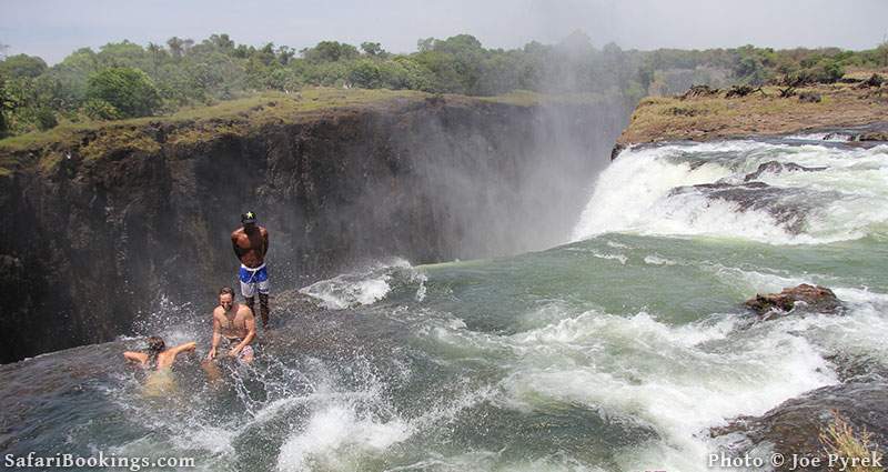
The River Zambezi, upstream from the falls, experiences a rainy season from late November to early April, and a dry season the rest of the year. The river's annual flood season is February to May with a peak in April,[10] The spray from the falls typically rises to a height of over 400 metres (1,300 ft), and sometimes even twice as high, and is visible from up to 50 km (30 mi) away. At full moon, a "moonbow" can be seen in the spray instead of the usual daylight rainbow. During the flood season, however, it is impossible to see the foot of the falls and most of its face, and the walks along the cliff opposite it are in a constant shower and shrouded in mist. Close to the edge of the cliff, spray shoots upward like inverted rain, especially at Zambia's Knife-Edge Bridge.
Knife Edge Bridge as of 2022
When the dry season takes effect, the islets on the crest become wider and more numerous, and in September to January up to half of the rocky face of the falls may become dry and the bottom of the First Gorge can be seen along most of its length. At this time it becomes possible (though not necessarily safe) to walk across some stretches of the river at the crest. It is also possible to walk to the bottom of the First Gorge at the Zimbabwean side. The minimum flow, which occurs in November, is around a tenth of the April figure; this variation in flow is greater than that of other major falls, and causes the Victoria Falls' annual average flow rate to be lower than might be expected based on the maximum flow.[11] In 2019 unusually low rain dramatically reduced the fall to the lowest flow in a century. Global climate change and changed climate patterns are suggested to have caused this.
2. Tanzania

Tanzania , officially the United Republic of Tanzania (Swahili: Jamhuri ya Muungano wa Tanzania), is a country in East Africa within the African Great Lakes region. It borders Uganda to the north; Kenya to the northeast; Comoro Islands and the Indian Ocean to the east; Mozambique and Malawi to the south; Zambia to the southwest; and Rwanda, Burundi, and the Democratic Republic of the Congo to the west. Mount Kilimanjaro, Africa's highest mountain, is in northeastern Tanzania.
Many important hominid fossils have been found in Tanzania, such as 6-million-year-old Pliocene hominid fossils. The genus Australopithecus ranged across Africa between 4 and 2 million years ago, and the oldest remains of the genus Homo are found near Lake Olduvai. Following the rise of Homo erectus 1.8 million years ago, humanity spread all over the Old World, and later in the New World and Australia under the species Homo sapiens. H. sapiens also overtook Africa and absorbed the older species of humanity.
Later in the Stone and Bronze Age, prehistoric migrations into Tanzania included Southern Cushitic speakers who moved south from present-day Ethiopia; Eastern Cushitic people who moved into Tanzania from north of Lake Turkana about 2,000 and 4,000 years ago and the Southern Nilotes, including the Datoog, who originated from the present-day South Sudan-Ethiopia border region between 2,900 and 2,400 years ago.page 18 These movements took place at about the same time as the settlement of the Mashariki Bantu from West Africa in the Lake Victoria and Lake Tanganyika areas. They subsequently migrated across the rest of Tanzania between 2,300 and 1,700 years ago.
German rule began in mainland Tanzania during the late 19th century when Germany formed German East Africa. This was followed by British rule after World War I. The mainland was governed as Tanganyika, with the Zanzibar Archipelago remaining a separate colonial jurisdiction. Following their respective independence in 1961 and 1963, the two entities merged in 1964 to form the United Republic of Tanzania. The countries had joined the British Commonwealth in 1961 and Tanzania is still a member of the Commonwealth as one republic.
The United Nations estimated Tanzania's population at 63.59 million, which is slightly smaller than South Africa and makes it the second-most populous country located entirely south of the Equator. The population is composed of about 120 ethnic, linguistic, and religious groups. The sovereign state of Tanzania is a presidential constitutional republic and since 1996 its official capital city has been Dodoma where the president's office, the National Assembly, and all government ministries are located. Dar es Salaam, the former capital, retains most government offices and is the country's largest city, principal port, and leading commercial centre. Tanzania is a de facto one-party state with the democratic socialist Chama Cha Mapinduzi party in power.
Tanzania is mountainous and densely forested in the north-east, where Mount Kilimanjaro is located. Three of Africa's Great Lakes are partly within Tanzania. To the north and west lie Lake Victoria, Africa's largest lake, and Lake Tanganyika, the continent's deepest lake, known for its unique species of fish. To the south lies Lake Malawi. The eastern shore is hot and humid, with the Zanzibar Archipelago just offshore. The Menai Bay Conservation Area is Zanzibar's largest marine protected area. The Kalambo Falls, located on the Kalambo River at the Zambian border, is the second-highest uninterrupted waterfall in Africa.
Christianity is the largest religion in Tanzania, but there are also substantial Muslim and Animist minorities. Over 100 different languages are spoken in Tanzania, making it the most linguistically diverse country in East Africa. The country does not have a de jure official language, although the national language is Swahili. Swahili is used in parliamentary debate, in the lower courts, and as a medium of instruction in primary school. English is used in foreign trade, in diplomacy, in higher courts, and as a medium of instruction in secondary and higher education; although the Tanzanian government is planning to discontinue English as the primary language of instruction, it will be available as an optional course. Approximately 10% of Tanzanians speak Swahili as a first language, and up to 90% speak it as a second language.
3. Zanzibar

Zanzibar Swahili: Zanzibar; Arabic: زِنْجِبَار, romanized: Zinjibār) is an insular semi-autonomous state which united with Tanganyika in 1964 to form the United Republic of Tanzania. It is an Archipelago in the Indian Ocean, 25-50 kilometres (16-31 mi) off the coast of the mainland, and consists of many small islands and two large ones: Unguja (the main island, referred to informally as Zanzibar) and Pemba Island. The capital is Zanzibar City, located on the island of Unguja. Its historic centre, Stone Town, is a World Heritage Site.
Zanzibar's main industries are spices, raffia and tourism. In particular, the islands produce cloves, nutmeg, cinnamon, and black pepper. For this reason, the Zanzibar Archipelago, together with Tanzania's Mafia Island, are sometimes referred to locally as the "Spice Islands". Tourism in Zanzibar is a more recent activity, driven by government promotion that caused an increase from 19,000 tourists in 1985, to 376,000 in 2016. The islands are accessible via 5 ports and the Abeid Amani Karume International Airport, which can serve up to 1.5 million passengers per year.
Zanzibar's marine ecosystem is an important part of the economy for fishing and algaculture and contains important marine ecosystems that act as fish nurseries for Indian Ocean fish populations. Moreover, the land ecosystem is the home of the endemic Zanzibar red colobus, the Zanzibar servaline genet, and the extinct or rare Zanzibar leopard. Pressure from the tourist industry and fishing as well as larger threats such as sea level rise caused by climate change are creating increasing environmental concerns throughout the region.
The word Zanzibar came from Arabic zanjibār (زنجبار [zandʒibar]), which is in turn from Persian zangbâr (زنگبار [zæŋbɒɾ]), a compound of Zang (زنگ [zæŋ], "black") + bâr (بار [bɒɾ], "coast"),[14][15][16] cf. the Sea of Zanj. The name is one of several toponyms sharing similar etymologies, ultimately meaning "land of the blacks" or similar meanings, in reference to the dark skin of the inhabitants.
4. Serengeti National Park

The Serengeti National Park is a large national park in northern Tanzania that stretches over 14,763 km2 (5,700 sq mi).[1] It is located entirely in eastern Mara Region and north east portion of Simiyu Region and contains over 15,000,000 hectares (37,000,000 acres) of virgin savanna. The park was established in 1940.
The Serengeti is well known for the largest annual animal migration in the world of over 1.5 million blue wildebeest and 250,000 zebra and the largest lion population in Africa. It is under threat from deforestation, population growth and ranching.
The park covers 14,750 km2 (5,700 sq mi) of grassland plains, savanna, riverine forest, and woodlands. The park lies in northwestern Tanzania, bordered to the north by the Kenyan border, where it is continuous with the Maasai Mara National Reserve. To the southeast of the park is the Ngorongoro Conservation Area, to the southwest lies Maswa Game Reserve, to the west are the Ikorongo and Grumeti Game Reserves, and to the northeast and east lies the Loliondo Game Control Area.
The landscape of the Serengeti Plain is extremely varied, ranging from savannah to hilly woodlands to open grasslands. The region's geographic diversity is due to the extreme weather conditions that plague the area, particularly the potent combination of heat and wind. The diverse habitats in the region may have originated from a series of volcanoes, whose activity shaped the basic geographic features of the plain by adding mountains and craters to the landscape.[citation needed]
The Mara River, which flows through Maasai Mara National Reserve from the Kenyan highlands to Lake Victoria, is the only permanently-flowing river in the Serengeti ecosystem.
The park is divided into three regions:
Serengeti plains: The best-known feature of the Serengeti is the almost treeless grassland in the south. It has kopjes, granite formations that serve as observation posts for predators. The Volcanic Grasslands is a edaphic plant community that grows on soils derived from volcanic ash from nearby volcanos.[citation needed]
Western corridor: The main geographic feature is the pair of rivers, Grumeti and Mbalageti. There are big groups of riverine forest and some small mountain ranges. The great migration passes through the corridor from May to July. It stretches to Lake Victoria. The area is flatter than the northern parts of the park and more densely covered with plants than the southern plains.[citation needed]
Northern Serengeti: the landscape is dominated by open woodlands, predominantly Commiphora and hills, ranging from Seronera in the south to the Mara River on the Kenyan border. It is remote and relatively inaccessible.[citation needed]
5. Mauritius

Mauritius, officially the Republic of Mauritius, is an island nation in the Indian Ocean about 2,000 kilometres (1,200 mi) off the southeast coast of the African continent, east of Madagascar. It includes the main island (also called Mauritius), as well as Rodrigues, Agaléga and St. Brandon. The islands of Mauritius and Rodrigues, along with nearby Réunion (a French overseas department), are part of the Mascarene Islands. The main island of Mauritius, where most of the population is concentrated, hosts the capital and largest city, Port Louis. The country spans 2,040 square kilometres (790 sq mi) and has an exclusive economic zone covering 2,300,000 square kilometres (890,000 sq mi).
Arab sailors were the first to discover the uninhabited island, around 975, and they called it Dina Arobi. The earliest confirmed discovery was in 1507 by Portuguese sailors, who otherwise took little interest in the islands. The Dutch took possession in 1598, establishing a succession of short-lived settlements over a period of about 120 years, before abandoning their efforts in 1710. France took control in 1715, renaming it Isle de France. In 1810, the United Kingdom seized the island, and four years later, in the Treaty of Paris (1814), France ceded Mauritius and its dependencies to the United Kingdom. The British colony of Mauritius included Rodrigues, Agaléga, St. Brandon, Tromelin, the Chagos Archipelago, and, until 1906, the Seychelles. Mauritius and France dispute sovereignty over Tromelin as the Treaty of Paris failed to mention it specifically. Mauritius remained a primarily plantation-based colony of the United Kingdom until independence in 1968.
In 1965, three years before Mauritius became independent, the UK split off the Chagos Archipelago from Mauritian territory, and also split off the islands of Aldabra, Farquhar, and Desroches from the Seychelles, to form the British Indian Ocean Territory (BIOT). The local population was forcibly expelled and the largest island, Diego Garcia, was leased to the United States. The UK has restricted access to the Chagos Archipelago, barring entry to casual tourists, the media, and former inhabitants. The sovereignty of the Chagos is disputed between Mauritius and the UK. In February 2019, the International Court of Justice issued an advisory opinion ordering the UK to return the Chagos Islands to Mauritius as rapidly as possible to complete the decolonisation of Mauritius.
Owing to its geographic location and centuries of colonialism, the people of Mauritius are highly diverse in ethnicity, culture, language and faith. It is the only country in Africa where Hinduism is the most practised religion. Indo-Mauritians make up the bulk of the population with significant Creole, Sino-Mauritian and Franco-Mauritian minorities. The island's government is closely modelled on the Westminster parliamentary system and Mauritius is highly ranked for economic and political freedom along with being the only African country with full democracy. Mauritius is also the continent's only country with "very high" Human Development Index. According to the World Bank, the country is classified as a high-income economy. Mauritius is also ranked as the most competitive, and one of the most developed economies in the African region. The country is a welfare state. The government provides free universal healthcare, free education up through the tertiary level and free public transportation for students, senior citizens, and the disabled. In 2019, Mauritius was ranked the most peaceful African country by the Global Peace Index.
Along with the other Mascarene Islands, Mauritius is known for its varied flora and fauna. Many species are endemic to the island. The island was the only known home of the dodo, which, along with several other avian species, was made extinct by human activities relatively soon after the island's settlement. There are other endemic animals like for example: the Mauritian parakeet, the kestrel, and the pink pigeon.[citation needed]
6. Cairo

Cairo is the capital of Egypt and the largest city in the Arab world. The Greater Cairo metropolitan area, with a population of 21.3 million, is the largest urban agglomeration in Africa, the largest in the Arab world and the Middle East, and the sixth-largest in the world by population. Cairo is associated with ancient Egypt, as the Giza pyramid complex and the ancient cities of Memphis and Heliopolis are located in its geographical area. Located near the Nile Delta, the city first developed as Fustat, a settlement founded after the Muslim conquest of Egypt in 640 next to an existing ancient Roman fortress, Babylon. Under the Fatimid dynasty a new city, al-Qāhirah, was founded nearby in 969. It later superseded Fustat as the main urban centre during the Ayyubid and Mamluk periods (12th-16th centuries). Cairo has long been a centre of the region's political and cultural life, and is titled "the city of a thousand minarets" for its preponderance of Islamic architecture. Cairo's historic center was awarded World Heritage Site-status in 1979. Cairo is considered a World City with a "Beta +" classification according to GaWC.
Today, Cairo has the oldest and largest cinema and music industry in the Arab World, as well as the world's second-oldest institution of higher learning, Al-Azhar University. Many international media, businesses, and organizations have regional headquarters in the city; the Arab League has had its headquarters in Cairo for most of its existence.
With a population of over 10 million spread over 453 km2 (175 sq mi), Cairo is by far the largest city in Egypt. An additional 9.5 million inhabitants live in close proximity to the city. Cairo, like many other megacities, suffers from high levels of pollution and traffic. The Cairo Metro, opened in 1987, is the oldest metro system in Africa, and ranks amongst the fifteen busiest in the world, with over 1 billion annual passenger rides. The economy of Cairo was ranked first in the Middle East in 2005, and 43rd globally on Foreign Policy's 2010 Global Cities Index.
The area around present-day Cairo had long been a focal point of Ancient Egypt due to its strategic location at the junction of the Nile Valley and the Nile Delta regions (roughly Upper Egypt and Lower Egypt), which also placed it at the crossing of major routes between North Africa and the Levant. Memphis, the capital of Egypt during the Old Kingdom and a major city up until the Ptolemaic period, was located a short distance south of present-day Cairo. Heliopolis, another important city and major religious center, was located in what are now the northeastern suburbs of Cairo. It was largely destroyed by the Persian invasions in 525 BC and 343 BC and partly abandoned by the late first century BC.
However, the origins of modern Cairo are generally traced back to a series of settlements in the first millennium AD. Around the turn of the fourth century, as Memphis was continuing to decline in importance, the Romans established a large fortress along the east bank of the Nile. The fortress, called Babylon, was built by the Roman emperor Diocletian (r. 285-305) at the entrance of a canal connecting the Nile to the Red Sea that was created earlier by emperor Trajan (r. 98-115). Further north of the fortress, near the present-day district of al-Azbakiya, was a port and fortified outpost known as Tendunyas (Coptic: ϯⲁⲛⲧⲱⲛⲓⲁⲥ) or Umm Dunayn. While no structures older than the 7th century have been preserved in the area aside from the Roman fortifications, historical evidence suggests that a sizeable city existed. The city was important enough that its bishop, Cyrus, participated in the Second Council of Ephesus in 449. However, the Byzantine-Sassanian War between 602 and 628 caused great hardship and likely caused much of the urban population to leave for the countryside, leaving the settlement partly deserted. The site today remains at the nucleus of the Coptic Orthodox community, which separated from the Roman and Byzantine churches in the late 4th century. Cairo's oldest extant churches, such as the Church of Saint Barbara and the Church of Saints Sergius and Bacchus (from the late 7th or early 8th century), are located inside the fortress walls in what is now known as Old Cairo or Coptic Cairo.
7. Masai Mara National Reserve

Maasai Mara, also sometimes spelled Masai Mara and locally known simply as The Mara, is a large national game reserve in Narok, Kenya, contiguous with the Serengeti National Park in Tanzania. It is named in honor of the Maasai people, the ancestral inhabitants of the area, who migrated to the area from the Nile Basin. Their description of the area when looked at from afar: "Mara" means "spotted" in the local Maasai language, due to the many short bushy trees which dot the landscape.
Maasai Mara is one of the most famous and important wildlife conservation and wilderness areas in Africa, world-renowned for its exceptional populations of lion, African leopard, cheetah and African bush elephant. It also hosts the Great Migration, which secured it as one of the Seven Natural Wonders of Africa, and as one of the ten Wonders of the World.
The Greater Mara ecosystem encompasses areas known as the Maasai Mara National Reserve, the Mara Triangle, and several Maasai Conservancies, including Koiyaki, Lemek, Ol Chorro Oirowua, Mara North, Olkinyei, Siana, Maji Moto, Naikara, Ol Derkesi, Kerinkani, Oloirien, and Kimintet.
The total area under conservation in the Greater Maasai Mara ecosystem amounts to almost 1,510 km2 (580 sq mi). It is the northernmost section of the Mara-Serengeti ecosystem, which covers some 25,000 km2 (9,700 sq mi) in Tanzania and Kenya. It is bounded by the Serengeti Park to the south, the Siria / Oloololo escarpment to the west, and Maasai pastoral ranches to the north, east and west. Rainfall in the ecosystem increases markedly along a southeast-northwest gradient, varies in space and time, and is markedly bimodal. The Sand, Talek River and Mara River are the major rivers draining the reserve. Shrubs and trees fringe most drainage lines and cover hillslopes and hilltops.
The terrain of the reserve is primarily open grassland with seasonal riverlets. In the south-east region are clumps of the distinctive acacia tree. The western border is the Esoit (Siria) Escarpment of the East African Rift, which is a system of rifts some 5,600 km (3,500 mi) long, from Ethiopia's Red Sea through Kenya, Tanzania, Malawi and into Mozambique. Wildlife tends to be most concentrated here, as the swampy ground means that access to water is always good, while tourist disruption is minimal. The easternmost border is 224 km (139.2 mi) from Nairobi, and hence it is the eastern regions which are most visited by tourists.
It has a semi-arid climate with biannual rains and two distinct rainy seasons. Local farmers have referred to these as the 'long rains' which last approximately six to eight weeks in April and May and the 'short rains' in November and December which last approximately four weeks.
8. Cape Town

Cape Town is one of South Africa's three capital cities, serving as the seat of the Parliament of South Africa. It is the legislative capital of the country, the oldest city in the country, and the second largest (after Johannesburg). Colloquially named the Mother City, it is the largest city of the Western Cape province, and is managed by the City of Cape Town metropolitan municipality. The other two capitals are Pretoria, the executive capital, located in Gauteng, where the Presidency is based, and Bloemfontein, the judicial capital in the Free State, where the Supreme Court of Appeal is located.[10]
Cape Town is ranked as a Beta world city by the Globalization and World Cities Research Network. The city is known for its harbour, for its natural setting in the Cape Floristic Region, and for landmarks such as Table Mountain and Cape Point. Cape Town is home to 66% of the Western Cape's population. In 2014, Cape Town was named the best place in the world to visit by both The New York Times and The Daily Telegraph.
Located on the shore of Table Bay, the City Bowl area of Cape Town, is the oldest urban area in the Western Cape, with a significant cultural heritage. It was founded by the Dutch East India Company (VOC) as a supply station for Dutch ships sailing to East Africa, India, and the Far East. Jan van Riebeeck's arrival on 6 April 1652 established the VOC Cape Colony, the first permanent European settlement in South Africa. Cape Town outgrew its original purpose as the first European outpost at the Castle of Good Hope, becoming the economic and cultural hub of the Cape Colony. Until the Witwatersrand Gold Rush and the development of Johannesburg, Cape Town was the largest city in southern Africa.
The city has a long coastline on the Atlantic Ocean, which includes False Bay, and extends to the Hottentots Holland mountains in the East. The Table Mountain National Park is within the city boundaries and there are several other nature reserves and marine protected areas within and adjacent to the city, protecting the diverse terrestrial and marine natural environment.
The Cape Peninsula is a rocky and mountainous peninsula that juts out into the Atlantic Ocean at the south-western extremity of the continent. At its tip is Cape Point and the Cape of Good Hope. The peninsula forms the west side of False Bay and the Cape Flats. On the east side are the Helderberg and Hottentots Holland mountains. The three main rock formations are the late-Precambrian Malmebury group (sedimentary and metamorphic rock), the Cape Granite suit, comprising the huge Peninsula, Kuilsriver-Helderberg,and Stellenbosch batholiths, that were intruded into the Malmesbury Group about 630 million years ago, and the Table Mountain group sandstones that were deposited on the eroded surface of the granite and Malmesbury series basement about 450 million years ago. The sand, silt and mud deposits were lithified by pressure and then folded during the Cape Orogeny to form the Cape Fold Belt, which extends in an arc along the western and southern coasts. The present landscape is due to prolonged erosion having carved out deep valleys, removing parts of the once continuous Table Mountain Group sandstone cover from over the Cape Flats and False Bay, and leaving high residual mountain ridges.[18]
At times the sea covered the Cape Flats and Noordhoek valley and the Cape Peninsula was then a group of islands. During glacial periods the sea level dropped to expose the bottom of False Bay to weathering and erosion, with the last major regression leaving the entire bottom of False Bay exposed. During this period an extensive system of dunes was formed on the sandy floor of False Bay. At this time the drainage outlets lay between Rocky Bank Cape Point to the west, and between Rocky Bank and Hangklip Ridge to the east, with the watershed roughly along the line of the contact zone east of Seal Island and Whittle Rock.
9. Kruger National Park

Kruger National Park is a South African National Park and one of the largest game reserves in Africa. It covers an area of 19,623 km2 (7,576 sq mi) in the provinces of Limpopo and Mpumalanga in northeastern South Africa, and extends 360 km (220 mi) from north to south and 65 km (40 mi) from east to west. The administrative headquarters are in Skukuza. Areas of the park were first protected by the government of the South African Republic in 1898, and it became South Africa's first national park in 1926.
To the west and south of the Kruger National Park are the two South African provinces of Limpopo and Mpumalanga, respectively. To the north is Zimbabwe, and to the east is Mozambique. It is now part of the Great Limpopo Transfrontier Park, a peace park that links Kruger National Park with the Gonarezhou National Park in Zimbabwe, and with the Limpopo National Park in Mozambique.
The park is part of the Kruger to Canyons Biosphere, an area designated by the United Nations Educational, Scientific and Cultural Organization (UNESCO) as an International Man and Biosphere Reserve.
The park lies in the north-east of South Africa, in the eastern parts of Limpopo and Mpumalanga provinces. Phalaborwa, Limpopo is the only town in South Africa that borders the Kruger National Park. It is one of the largest national parks in the world, with an area of 19,485 km2 (7,523 sq mi). The park is approximately 360 km (220 mi) long, and has an average width of 65 km (40 mi). At its widest point, the park is 90 km (56 mi) wide from east to west. To the north and south of the park two rivers, the Limpopo and the Crocodile respectively, act as its natural boundaries. To the east the Lebombo Mountains separate it from Mozambique. Its western boundary runs parallel with this range, roughly 65 km (40 mi) distant. The park varies in altitude between 200 m (660 ft) in the east and 840 m (2,760 ft) in the south-west near Berg-en-Dal. The highest point in the park is here, a hill called Khandzalive. Several rivers run through the park from west to east, including the Sabie, Olifants, Crocodile, Letaba, Luvuvhu and Limpopo Rivers.
Over 420 recorded archaeological sites in Kruger Park attest to its occupation before modern times. Most sites however had relatively short occupation periods, as the presence of predators and the tsetse fly limited cattle husbandry. At Masorini hill, the H9 route, iron smelting was practiced up to the Mfecane era. The reconstructed Thulamela on a hilltop south of the Levuvhu River was occupied from the 13th to 16th centuries, and had links with traders from the African east coast.
Before the Second Anglo-Boer War, the area now covered by the park was a remote section of the eastern South African Republic's last wild frontier. Paul Kruger, President of the South African Republic at the time, proclaimed the area, which was inhabited by the Tsonga people, a sanctuary for the protection of its wildlife. James Stevenson Hamilton noted many kraals along the Sabi River and also further north beyond the Letaba River[7] although the north was sparsely populated compared to the south. Many of the local natives were employed by railway companies for construction of rail connections, notably that between Pretoria (now in South Africa) and Lorenço Marques (now Maputo, Mozambique) during the end of the 19th century. Abel Chapman, one of the hunters who noted that the area was over-hunted by the end of the 19th century, brought this fact to wider attention.
10. Seychelles

Seychelles is an archipelagic island country consisting of 115 islands in the Indian Ocean at the eastern edge of the Somali Sea. Its capital and largest city, Victoria, is 1,500 kilometres (800 nautical miles) east of mainland Africa. Nearby island countries and territories include the Comoros, Madagascar, Mauritius, and the French overseas regions of Mayotte and Réunion to the south; and Maldives and the Chagos Archipelago (administered by the United Kingdom as the British Indian Ocean Territory) to the east. It is the least populated sovereign African country, with an estimated 2020 population of 98,462.
Seychelles was uninhabited prior to being encountered by Europeans in the 16th century. It faced competing French and British interests until coming under full British control in the late 18th century. Since proclaiming independence from the United Kingdom in 1976, it has developed from a largely agricultural society to a market-based diversified economy, characterized by rapidly rising service, public sector, and tourism activities. From 1976 to 2015, nominal GDP grew nearly 700%, and purchasing power parity nearly 1600%. Since the late 2010s, the government has taken steps to encourage foreign investment.
Today, Seychelles boasts the highest nominal per capita GDP of any African nation. It has the second-highest Human Development Index of any African country after Mauritius. It is one of only two African countries classified as a high-income economy by the World Bank (the other being Mauritius).
On 26 October 2020, Wavel Ramkalawan, a 59-year old Anglican priest was elected the fifth President of the Republic of Seychelles. Ramkalawan was an opposition MP from 1993 to 2011, and from 2016 to 2020. He served as the Leader of the Opposition from 1998 to 2011 and from 2016 to 2020. Ramkalawan defeated incumbent Danny Faure by 54.9% to 43.5%. This marked the first time the opposition had won a presidential election.
The primary political parties are the former ruling socialist People's Party (PP), known until 2009 as the Seychelles People's Progressive Front (SPPF) now called United Seychelles (US), and the socially liberal Seychelles National Party (SNP).
The election of the National Assembly was held on 22-24 October 2020. The Seychelles National Party, the Seychelles Party for Social Justice and Democracy and the Seychelles United Party formed a coalition, Linyon Demokratik Seselwa (LDS). LDS won 25 seats and US got 10 seats of the 35 seats of the National Assembly.
11. Marrakech

Marrakesh or Marrakech is the fourth largest city in the Kingdom of Morocco.[2] It is one of the four Imperial cities of Morocco and is the capital of the Marrakesh-Safi region. The city is situated west of the foothills of the Atlas Mountains. Marrakesh is 580 km (360 mi) southwest of Tangier, 327 km (203 mi) southwest of the Moroccan capital of Rabat, 239 km (149 mi) south of Casablanca, and 246 km (153 mi) northeast of Agadir.
The region has been inhabited by Berber farmers since Neolithic times. The city was founded in 1070 by Emir Abu Bakr ibn Umar as the imperial capital of the Almoravid Empire. The Almoravids established the first major structures in the city and shaped its layout for centuries to come. The red walls of the city, built by Ali ibn Yusuf in 1122-1123, and various buildings constructed in red sandstone afterwards, have given the city the nickname of the "Red City" (المدينة الحمراء) or "Ochre City" (ville ocre). Marrakesh grew rapidly and established itself as a cultural, religious, and trading center for the Maghreb and sub-Saharan Africa. Jemaa el-Fnaa is the busiest square in Africa.
After a period of decline, the city was surpassed by Fez, and in the early 16th century, Marrakesh again became the capital of the kingdom. The city regained its preeminence under wealthy Saadian sultans Abdallah al-Ghalib and Ahmad al-Mansur, who embellished the city with sumptuous palaces such as the El Badi Palace (1578) and restored many ruined monuments. Beginning in the 17th century, the city became popular among Sufi pilgrims for its seven patron saints who are entombed here. In 1912 the French Protectorate in Morocco was established and T'hami El Glaoui became Pasha of Marrakesh and held this position nearly throughout the protectorate until the role was dissolved upon the independence of Morocco and the reestablishment of the monarchy in 1956.
Marrakesh comprises an old fortified city packed with vendors and their stalls. This medina quarter is a UNESCO World Heritage Site. Today it is one of the busiest cities in Africa and serves as a major economic center and tourist destination. Real estate and hotel development in Marrakesh have grown dramatically in the 21st century. Marrakesh is particularly popular with the French, and numerous French celebrities own property in the city. Marrakesh has the largest traditional market (souk) in Morocco, with some 18 souks selling wares ranging from traditional Berber carpets to modern consumer electronics. Crafts employ a significant percentage of the population, who primarily sell their products to tourists.
Marrakesh is served by Ménara International Airport and by Marrakesh railway station, which connects the city to Casablanca and northern Morocco. Marrakesh has several universities and schools, including Cadi Ayyad University. A number of Moroccan football clubs are here, including Najm de Marrakech, KAC Marrakech, Mouloudia de Marrakech and Chez Ali Club de Marrakech. The Marrakesh Street Circuit hosts the World Touring Car Championship, Auto GP and FIA Formula Two Championship races.
12. Madagascar

The Republic of Madagascar is an island country in the Indian Ocean, approximately 400 kilometres (250 miles) off the coast of East Africa across the Mozambique Channel. At 592,800 square kilometres (228,900 sq mi) Madagascar is the world's second-largest country that consists primarily of islands, after Indonesia. The nation consists of the island of Madagascar (the fourth-largest island in the world) and numerous smaller peripheral islands. Following the prehistoric breakup of the supercontinent Gondwana, Madagascar split from the Indian subcontinent around 88 million years ago, allowing native plants and animals to evolve in relative isolation. Consequently, Madagascar is a biodiversity hotspot; over 90% of its wildlife is endemic.
Human settlement of Madagascar occurred during or before the mid first millennium AD by Austronesian peoples, presumably arriving on outrigger canoes from present-day Indonesia. These were joined around the 9th century AD by Bantu migrants crossing the Mozambique Channel from East Africa. Other groups continued to settle on Madagascar over time, each one making lasting contributions to Malagasy cultural life. The Malagasy ethnic group is often divided into 18 or more subgroups, of which the largest are the Merina of the central highlands.
Until the late 18th century, the island of Madagascar was ruled by a fragmented assortment of shifting sociopolitical alliances. Beginning in the early 19th century, most of the island was united and ruled as the Kingdom of Madagascar by a series of Merina nobles. The monarchy ended in 1897 when the island was absorbed into the French colonial empire, from which the island gained independence in 1960. The autonomous state of Madagascar has since undergone four major constitutional periods, termed republics. Since 1992, the nation has officially been governed as a constitutional democracy from its capital at Antananarivo. However, in a 2009 political crisis, president Marc Ravalomanana was made to resign and presidential power was transferred in March 2009 to Andry Rajoelina. Constitutional governance was restored in January 2014, when Hery Rajaonarimampianina was named president following a 2013 election deemed fair and transparent by the international community. Madagascar is a member of the United Nations, the African Union (AU), the Southern African Development Community (SADC), and the Organisation Internationale de la Francophonie.
Madagascar belongs to the group of least developed countries, according to the United Nations. Malagasy and French are both official languages of the state. The majority of the population adheres to Christianity, traditional beliefs, or an amalgamation of the two. Ecotourism and agriculture, paired with greater investments in education, health, and private enterprise, are key elements of Madagascar's development strategy. Under Ravalomanana, these investments produced substantial economic growth, but the benefits were not evenly spread throughout the population, producing tensions over the increasing cost of living and declining living standards among the poor and some segments of the middle class. As of 2017, the economy has been weakened by the 2009-2013 political crisis, and quality of life remains low for the majority of the Malagasy population.
13. Botswana

Botswana is a landlocked country in Southern Africa. Botswana is topographically flat, with up to 70 percent of its territory being the Kalahari Desert. It is bordered by South Africa to the south and southeast, Namibia to the west and north, and Zimbabwe to the northeast. It is connected to Zambia across the short Zambezi River border by the Kazungula Bridge.
A country of slightly over 2.3 million people, Botswana is one of the most sparsely populated countries in the world. About 11.6 percent of the population lives in the capital and largest city, Gaborone. Formerly one of the world's poorest countries—with a GDP per capita of about US$70 per year in the late 1960s—it has since transformed itself into an upper-middle-income country, with one of the world's fastest-growing economies.
Modern-day humans first inhabited the country over 200,000 years ago. The Tswana ethnic group were descended mainly from Bantu-speaking tribes who migrated southward of Africa to modern Botswana around 600 AD, living in tribal enclaves as farmers and herders. In 1885, the British colonised the area and declared a protectorate under the name of Bechuanaland. As decolonisation occurred, Bechuanaland became an independent Commonwealth republic under its current name on 30 September 1966. Since then, it has been a representative republic, with a consistent record of uninterrupted democratic elections and the lowest perceived corruption ranking in Africa since at least 1998.
The economy is dominated by mining, cattle, and tourism. Botswana has a GDP (purchasing power parity) per capita of about $18,113 as of 2021, one of the highest in Africa. Botswana is the world's biggest diamond producing country. Its relatively high gross national income per capita (by some estimates the fourth-largest in Africa) gives the country a relatively high standard of living and the highest Human Development Index of continental Sub-Saharan Africa. Botswana is the first African country to host Forbes 30 Under 30 and the 2017 Netball World Youth Cup.
Botswana is a member of the African Union, the Southern African Customs Union, the Southern African Development Community, the Commonwealth of Nations, and the United Nations. The country has been adversely affected by the HIV/AIDS epidemic. Despite the success in programmes to make treatments available, and to educate the populace about how to stop the spread of HIV/AIDS, the number of people with AIDS rose from 290,000 in 2005 to 320,000 in 2013. As of 2014, Botswana had the third-highest prevalence rate for HIV/AIDS, with roughly 20% of the population infected. However, in recent years the country has made strides in combatting HIV/AIDS, with efforts being made to provide proper treatment and lower the rate of mother-to-child transmission.
14. Luxor

Luxor is a modern city in Upper (southern) Egypt which includes the site of the Ancient Egyptian city of Thebes.
Luxor has frequently been characterized as the "world's greatest open-air museum", as the ruins of the Egyptian temple complexes at Karnak and Luxor stand within the modern city. Immediately opposite, across the River Nile, lie the monuments, temples and tombs of the west bank Theban Necropolis, which includes the Valley of the Kings and Valley of the Queens. Thousands of tourists from all around the world arrive annually to visit Luxor's monuments, contributing greatly to the economy of the modern city.
The population of Luxor is 422,407 (2021), with an area of approximately 417 square kilometres (161 sq mi). It is the capital of Luxor Governorate. It is among the oldest inhabited cities in the world.
Luxor was the ancient city of Thebes, the great capital of Upper Egypt during the New Kingdom, and the glorious city of Amun, later to become the god Amun-Ra. The city was regarded in the ancient Egyptian texts as wAs.t (approximate pronunciation: "Waset"), which meant "city of the sceptre", and later in Demotic Egyptian as ta jpt (conventionally pronounced as "tA ipt" and meaning "the shrine/temple", referring to the jpt-swt, the temple now known by its Arabic name Karnak, meaning "fortified village"), which the ancient Greeks adapted as Thebai and the Romans after them as Thebae. Thebes was also known as "the city of the 100 gates", sometimes being called "southern Heliopolis" ('Iunu-shemaa' in Ancient Egyptian), to distinguish it from the city of Iunu or Heliopolis, the main place of worship for the god Ra in the north. It was also often referred to as niw.t, which simply means "city", and was one of only three cities in Egypt for which this noun was used (the other two were Memphis and Heliopolis); it was also called niw.t rst, "southern city", as the southernmost of them.
The importance of the city started as early as the 11th Dynasty, when the town grew into a thriving city. Montuhotep II, who united Egypt after the troubles of the First Intermediate Period, brought stability to the lands as the city grew in stature. The Pharaohs of the New Kingdom in their expeditions to Kush, in today's northern Sudan, and to the lands of Canaan, Phoenicia and Syria saw the city accumulate great wealth and rose to prominence, even on a world scale. Thebes played a major role in expelling the invading forces of the Hyksos from Upper Egypt, and from the time of the 18th Dynasty to the 20th Dynasty, the city had risen as the political, religious and military capital of Ancient Egypt.
The city attracted peoples such as the Babylonians, the Mitanni, the Hittites of Anatolia (modern-day Turkey), the Canaanites of Ugarit, the Phoenicians of Byblos and Tyre, the Minoans from the island of Crete. A Hittite prince from Anatolia even came to marry with the widow of Tutankhamun, Ankhesenamun.[10] The political and military importance of the city, however, faded during the Late Period, with Thebes being replaced as political capital by several cities in Northern Egypt, such as Bubastis, Sais and finally Alexandria.
However, as the city of the god Amun-Ra, Thebes remained the religious capital of Egypt until the Greek period. The main god of the city was Amun, who was worshipped together with his wife, the Goddess Mut, and their son Khonsu, the God of the moon. With the rise of Thebes as the foremost city of Egypt, the local god Amun rose in importance as well and became linked to the sun god Ra, thus creating the new 'king of gods' Amun-Ra. His great temple at Karnak, just north of Thebes, was the most important temple of Egypt right until the end of antiquity.
Later, the city was attacked by Assyrian emperor Ashurbanipal who installed a new prince on the throne, Psamtik I. The city of Thebes was in ruins and fell in significance. However, Alexander the Great did arrive at the temple of Amun, where the statue of the god was transferred from Karnak during the Opet Festival, the great religious feast. Thebes remained a site of spirituality up to the Christian era, and attracted numerous Christian monks of the Roman Empire who established monasteries amidst several ancient monuments including the temple of Hatshepsut, now called Deir el-Bahri ("the northern monastery").
15. Namibia

Namibia is a country in Southern Africa. Its western border is the Atlantic Ocean. It shares land borders with Zambia and Angola to the north, Botswana to the east and South Africa to the south and east. Although it does not border Zimbabwe, less than 200 metres (660 feet) of the Botswanan right bank of the Zambezi River separates the two countries. Namibia gained independence from South Africa on 21 March 1990, following the Namibian War of Independence. Its capital and largest city is Windhoek. Namibia is a member state of the United Nations (UN), the Southern African Development Community (SADC), the African Union (AU) and the Commonwealth of Nations.
The driest country in sub-Saharan Africa, Namibia has been inhabited since pre-historic times by the San, Damara and Nama people. Around the 14th century, immigrating Bantu peoples arrived as part of the Bantu expansion. Since then, the Bantu groups, the largest being the Ovambo, have dominated the population of the country; since the late 19th century, they have constituted a majority. Today Namibia is one of the least densely populated countries in the world.
It has a population of 2.55 million people and is a stable multi-party parliamentary democracy. Agriculture, tourism and the mining industry including mining for gem diamonds, uranium, gold, silver and base metals form the basis of its economy, while the manufacturing sector is comparatively small.
In 1884, the German Empire established rule over most of the territory, forming a colony known as German South West Africa. Between 1904 and 1908, it perpetrated a genocide against the Herero and Nama people. German rule ended in 1915 with a defeat by South African forces. In 1920, after the end of World War I, the League of Nations mandated administration of the colony to South Africa. As mandatory power, South Africa imposed its laws, including racial classifications and rules. From 1948, with the National Party elected to power, this included South Africa applying apartheid to what was then known as South West Africa. In the later 20th century, uprisings and demands for political representation by native African political activists seeking independence resulted in the UN assuming direct responsibility over the territory in 1966, but South Africa maintained de facto rule. In 1973, the UN recognised the South West Africa People's Organisation (SWAPO) as the official representative of the Namibian people. Following continued guerrilla warfare, Namibia obtained independence in 1990. However, Walvis Bay and the Penguin Islands remained under South African control until 1994.